

LEVELLING :- very important definition and terms.

👇 For surveying quiz go down 👇 👇
LEVELLING :-
Levelling is a branch of surveying the object of which is :
( 1 ) to find the elevations of given points With respect to a given or assumed datum , and( 2 ) to establish Points at a given elevation or at different elevations with respect to a given or assumed datum .
Levelling deals with measurements in a vertical plane .
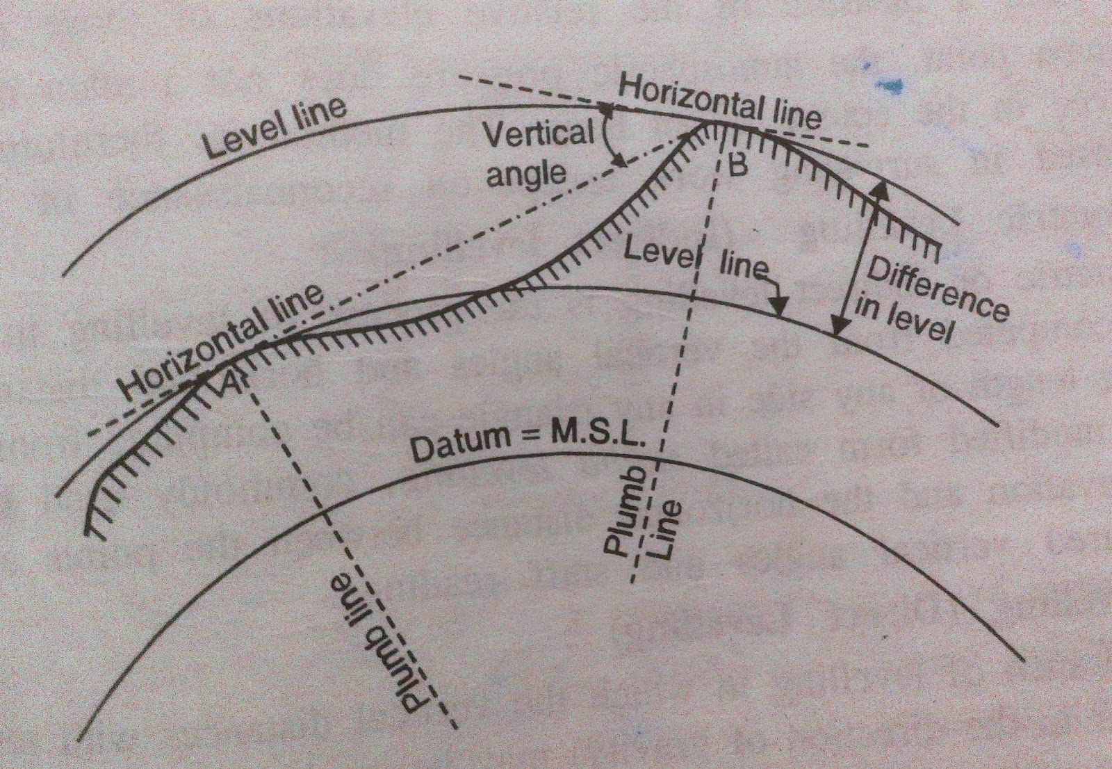
1. Level Surface :- A level surface is defined as a curved surface which at each point is perpendicular to the direction of gravity at the point . The surface of a still water is a truly level surface . Any surface parallel to the mean spheroidal surface of the earth is , therefore , a level surface .
2. Level Line .:- A level line is a line lying in a level surface . It is , therefore , normal to the plumb line at all points .
3. Horizontal Plane:- Horizontal plane through a point is a plane tangential to the level Surface at that point . It is , therefore , perpendicular to the plumb line through the point .
4. Horizontal Line:- . It is straight line tangential to the level line at a Point . It is also perpendicular to the PLUMBE line .
5. Vertical Line :- It is a line normal to the level line at a point .it is commonly considered to be the line defined by a plumb line .
6. Datum ,:- Datum is any surface to which elevations are referred . The mean Sea level affords a convenient datum / world over , and elevations are commonly given as So much above or below sea level . It is often more convenient , however , to assume some other datum , specially if only the relative elevations of points are required .
7. Elevation :- The elevation of a point on or near the surface of the earth is its vertical distance above or below an arbitrarily assumed level surface or datum . The difference in elevation between two points is the vertical distance between the two level surfaces in which the two points lie .
8. Vertical Angle:- . Vertical angle is an angle between two intersecting lines in a vertical plane . Generally , one of these lines is horizontal .
9. Mean Sea Level :-. Mean sea level is the average height of the sea for all stages of the tides . At any particular place it is derived by averaging the hourly tide heights over a long period of 19 years .
10. Bench Mark .:- Bench Mark is a relatively permanent point of reference whose elevation with respect to some assumed datum is known . It is used either as a starting Point for levelling or as a point upon which to close as a check .
11. Station :- In levelling , a station is that point where the level rod is held and not Where level is set up. It is the point whose elevation is to be ascertained or the point that is to be established at a given elevation.
12. Height of Instrument ( H . L ) :- For any set up of the level , the height of instrument is the elevation of plane of sight ( line of sight ) with respect to the assumed datum . It does not mean the height of the telescope above the ground where the level stands .
13. back Sight ( B . S . ) :- . Back sight is the sight taken on a rod held at a point that of known elevation , to ascertain the amount by which the line of sight is above point and thus to obtain the height of the instrument . Back sighting is equivalent to measuring up from the point of known elevation to the line of sight . It is also known as a plus Sight
as the back sight reading is always added to the level of the datum to get the height of the instrument .
The object of back sighting is , therefore , to ascertain the height of the plane of sight .
14. Fore Sight ( F . S . ) .:- Fore sight is a sight taken on a rod held at a point of unknown elevation , to ascertain the amount by which the point is below the line of Sight and thus to obtain the elevation of the station . Fore sighting is equivalent to measuring down from the line of sight .
It is also known as a minus sight as the fore sight reading is always subtracted ( except in special cases of tunnel survey ) from the height of the instrument to get the elevation of the point .
The object of fore sighting is , therthere, to ascertain the elevation of the point.
15. Turning Point ( T . P . ) :-. Turning point or change point is a point on which both minus sight and plus sight are taken on a line of direct levels. The minus Sight ( fore Sight ) is taken on the point in one set of instrument to ascertain the elevation of the point while the plus Sight ( back sight ) is taken on the same point in other set of the instrument to establish the new height of the instrument .
16. Intermediate Station ( I . S . ) .:- Intermediate station is a point , intermediate between two turning points , on which only one sight ( minus sight ) is taken to determine the elevation of the station.
Thanks you guys.........
Don't be self employed guys
Please share this important topic to your friends ::--
NOW ITS SURVEYING QUIZ TIME...
@@

1 Comments
Thank you for this post, this post is very helpfull for me provide all information about needle bearing.
ReplyDeleteNeedle Roller
Cylindrical Rollers
Needle Roller Bearing
Needle Bearing
HF Bearing