

Plane Table Surveying
• It is a graphical method of surveying in which field work andplotting are done simultaneously
• It is mainly used for small and medium scale mapping (1:10 000 to1: 25 00 000)
• Before starting plane table surveying, at first control stations areestablished to cover entire area, then a suitable scale is decided
• After that surveyor starts collecting details from either of thepoint and traverses all the stations
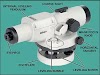
• Elevation of points of observation are determined with the help oflevelling, Indian Clinometer and telescopic alidade

Advantages of Plane Table Surveying
• It is suitable for location of details as well as contouring for large scale maps directly in the field.
• As surveying and plotting are done simultaneously in the field, chances of getting omission of any detail get less.
• The plotting details can immediately get compared with the actual objects present in the field. Thus errors as well as accuracy of the plot can be ascertained as the workprogresses in the field.
• Contours and specific features can be represented and checked conveniently as the whole area is in view at the time of plotting.
• Only relevant details are located because the map is drawn as the survey progresses.Irrelevant details get omitted in the field itself.
• The plane table survey is generally more rapid and less costly than most other types of survey.
• As the instruments used are simple, not much skill for operation of instruments isrequired. This method of survey requires no field book.
Disadvantages of Plane Table Surveying
• The plane table survey is not possible in unfavorable climates suchas rain, fog etc.
• This method of survey is not very accurate and thus unsuitable for large scale or precise work.
• As no field book is maintained, plotting at different scale require full exercise.
• The method requires large amount of time to be spent in the field.
• Quality of the final map depends largely on the drafting capability of the surveyor.
• This method is effective in relatively open country where stations can be sighted easily .

1 Comments
Nice explained
ReplyDelete